Paraglidingspots.com is a non-profit website for paragliding (and hanggliding) pilots who want to discover new flying areas. With a simple download you get a free of charge 'KMZ'-database with so far over 15.000 international launches and landing zones, for browsing with Google Earth.
Additionally, I offer waypoint files for GPS navigation instruments.
With paraglidingspots.com you get the complete picture, worldwide.
Info
For many pilots one of the nice things paragliding offers is discovering new sites and countries. When scouting around with your wing, you want to avoid to drive around for nothing. Therefore the coordinates should be correct. And you also want to evaluate wether a site is interesting for you or not. So far, site research in the internet can be time-consuming and sometimes frustrating. For example, the positions of many sites are misreported.
For paraglidingspots.com, I collect information from various sources, then evaluate and summarize them. The goal is to offer all flyable sites at one glance, worldwide, and above all: reliable coordinates.
I use Google Earth, because it is free, and it is the best for this purpose. The 3D terrain view and the possibility to load and view XC cross country flights lead to a quick understanding of new areas. On top, you can calculate a go-to route and explore the surroundings with Google Earth.
Please note: my database is the only one available where interesting and less interesting sites can be individuated at one glance. Red Text means: good spot, you should try if you are around. Additional red symbol means: very frequented, super spot.
Under "Further Downloads" I offer waypoints that can be used with TomTom or Garmin GPS navigation instruments.
So next time before you travel you can make some research on your computer, with the help of my Google Earth file and once being on the road or in the air, you can navigate directly to the spots using the waypoints.
|
|
- Install the program Google Earth, if not already done. If possible, use a computer with good performance, and a fast Internet connection.
- Settings Google Earth: I suggest to activate only the following layers: places / boarders / photos / mountains (to view 3D) for the start. Eventually also streets. Unclick all other layers, otherwise the buildup might be slow and shows too many details.
- Load the paraglidingspots database, it will open up automatically with Google Earth. (PLEASE NOTE - opening of the file for the first time will take some time, be patient. After you have saved it on your computer, it is much faster at next program start.) To further speed up working with GE, maximise the usable cache under 'Tools/Options'.
- Once the database is opened in Google Earth
- deactivate all countries and sites on the left column of you Google Earth window which you do not need (click away the hooks - you can always reactivate them)
- zoom in where you want to go - otherwise you will not see any details
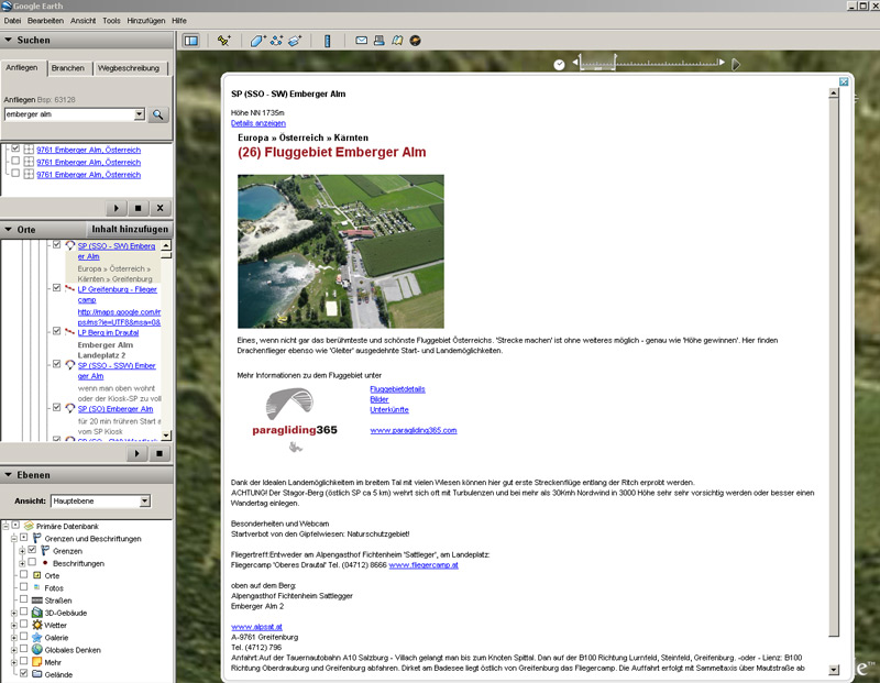
- click with the left mouse button to an icon. A window with further site information will open.
- Regularly check my website and load updates. PLEASE NOTE - when uploading a new database you should eliminate the old version, and shift the new one from 'temporary' to 'my places' - otherwise you will have copies of each spot, and you do not know which are new.
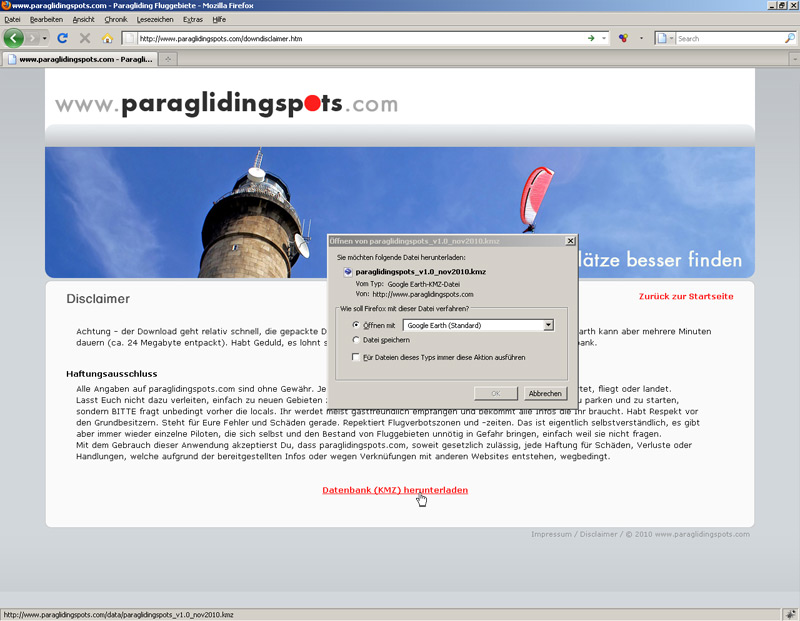
Download database

Open database with
Google Earth
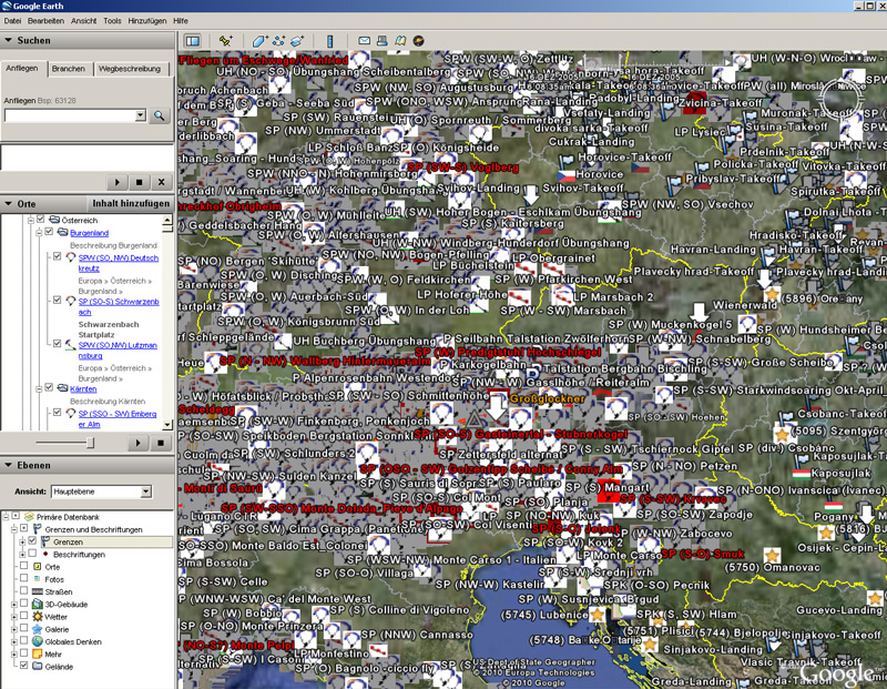
Choose a region
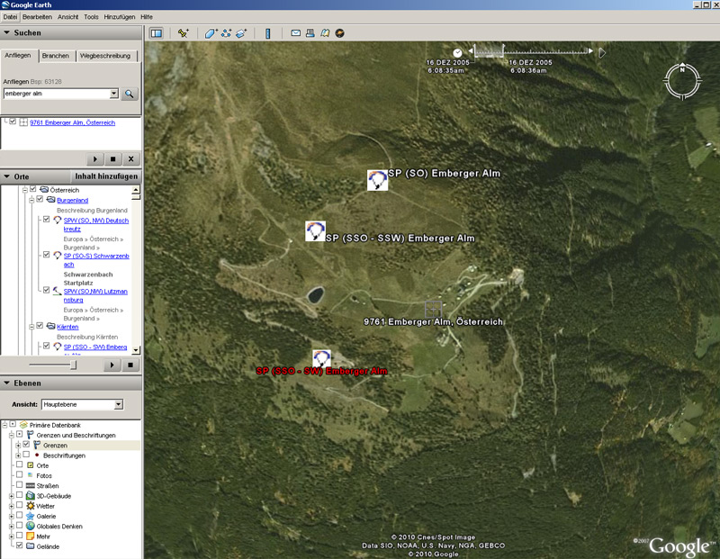
Zoom in
Left click:
description of flying area

Track area in 3D
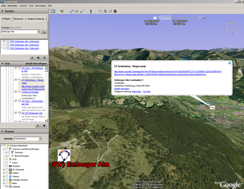
View landing site

Load and fly distance flights

Calculate approach
Entering and controlling the spots in GE takes a lot of time. I collect infos and coordinates from various sources (see below), try to verify them, avoid copies, add details.
It would have been possible just to link existing wiki style databases - like the nice iPhone-App where2fly.ch, which uses pgearth and flyland data. But this only works with a reliable and complete database (see my comments under 'Sources'). Advantage: the operator does not have to bother about the original data, which is maintained by the public. Disadvantages - there is no administrative data control and the wiki principle (everyone who uses it should try to improve data quality) is not understood by the most. Users take generously, but give almost nothing. Therefore the basis info from international web databases is often non complete, wrong, or not up to date.
So I decided to make the database manually and to use all sources known to me. Often coordinates have to be investigated. Try to test the result: compare my data for a country of your choice with the google earth data you know so far. You will see a great quality difference. Obviously my system bears the danger to get outdated - but if you find my database benificial and I get feedback, I will constantly improve quality.
If you like paraglidingspots.com, take part and share your information!
What is important when you look for new sites?
- GPS coordinates, launch and landing
- type of flight: mountain/coast/towing - soaring, thermic, XC...
- launch orientation
- height of launch, height difference to landing
- How to get there / how to get up
- suitable for whom
- hints, dangers, contacts, accomodation
These informations are collected from a large number of sources, e.g.:
- paraglidingearth.com: a good mine of information to get a general overview, worldwide. The concept is good, coordinates also relatively good. Details sometimes scarce and many copies where data stem from leonardo and not from users.
- www.paragliding365.com: often used, international overview. Concept also good, but coordinates mostly are incorrect. There is a large number of copies with different names and coordinates, meaning the same site. Anyhow, many infos from pg365 are worth its weight in gold.
- ozreport.com/data/sites.link.kmz: many international spots from 'The Oz Report' / USA. Sites which you do do not find elsewhere - especially for America. But it does not seem to be updated very often.
- www.xcontest.org, these XC flight databases are very helpful to evaluate the launch positions and to to separate the wheat from the chaff (finding sites with potential). Often site names are wrong, and there are many copies, because gps loggers track only after some time in the air.
- federation.ffvl.fr: the official French database - large in numbers, but the realiablity of the information varies.
- www.zonasdevuelo.com for Spain, a nice add-on. Often no coordinates
- flightlog.org: originally a source for sites in Norway, now also many international sites are described. User experience could be improved.
- www.vhpa.org.au/siteguide.html: site guide of the Australian Hanggliding Federation, very good and updated.
- websites of clubs: detailed infos, but often no usable coordinates.
- websites of schools and PG travel organisers: due to the commercial background often no coordinates.
- private and forum blogs from pilots: very good detail info, but often outdated
- Some national PG/HG organisations do not want their data to be published, e.g. the Danes. Too many foreign pilots misbehaved they say. You can discuss that for a long time with no conclusion. I think differently and give you all 'Flyvesteder' Infos from Denmark. Anyhow, please always ask the locals and behave respectful, especially in Denmark.
- Reports from PG magazines: often very good.
- Asking buddies and locals: in the end this is the best you can do - to be safe that you are going where you want to be.
In many countries people do not use websites to spread infos and just fly, locally. So if you have good new sources, please drop me a mail!
Have fun, be safe ... and see you up there